Big Bend National Park is one of two national parks in Texas. Located on the Texas-Mexico border, this park is remote and vast. If you have ever been to the rest of Texas, you will know this place is like no other in the state. There is no need for strenuous hikes to see big views, ancient dormant volcano, dinosaur fossils, Rio Grande River, and canyons. These and so much more can be seen from easy and moderate Big Bend hikes.
Disclaimer: This post may contain affiliate links so if you make a purchase or booking through one of our links we might earn a small commission (but don’t worry, it’s no extra cost to you).
Free Big Bend Itinerary – 5 Days
It may take several minutes to show up in your Inbox.
Where to Stay
Finding a place to stay is one of the biggest challenges when trekking Big Bend hikes. Chisos Mountains Lodge is located inside the park, but only has a limited number of rooms. It can be very difficult to get reservations here. Also inside the park are several campgrounds where you can RV or tent camp. Your options outside the park are just as limited as inside the park. The small towns of Study Butte, Terlingua, Marathon, and Alpine have some lodging and camping options as well. Study Butte and Terlingua are located just outside the Big Bend entrance gate. Marathon and Alpine are a bit further away and will require a decent commute to and from the park.
Best Time to Visit Big Bend
The best times of the year to trek Big Bend hikes is during the spring and fall months due to cooler temperatures. March is the busiest time of the year due to ideal weather and families on Spring Break vacations. This is when I visited, and I can attest to the busyness. During these times, park rangers block traffic to enter crowded areas and trails. I highly recommend arriving very early or fairly late in the afternoon if you are visiting in March. Summers can be too hot and winters too cold to visit this desert national park.
Big Bend Entrance Fees
You will need to purchase a park pass to enter Big Bend National Park. The cost is $30 per private vehicle or $15 per person for those 16 and older. The park pass is good for 7 consecutive days. If you frequent national parks, you should purchase an America the Beautiful park pass, which will allow you into all national parks and NPS lands for a year. Also, if you have a 4th grader in your household, you can get a family pass to the national parks that is good for a year. Find out more about that benefit here.
How to Get Around
The best vehicle for getting around Big Bend National Park is a 4×4 vehicle. Many of the roads within Big Bend will require it. There are three main areas in Big Bend: Chisos Basin, Ross Maxwell Scenic Drive, and Rio Grande Village. The Big Bend hikes are generally located in one of these three areas, and it can take up to an hour and a half to get from one area to another.
What to Pack for Big Bend
- Light Jacket – Make sure to dress in layers with this men’s and women’s light jacket.
- Hiking Shoes – These men’s and women’s hiking shoes are perfect for the slick rock on the trails.
- Soft Sided Ice Chest – Get this to keep your drinks cool and pack sandwich stuff for lunch on your Big Bend hikes.
- Leggings – Fleece lined leggings will give you a little extra warmth especially in the cold mornings and evenings.
- Bug Spray – Keep the bugs from pestering you!
- Refillable Water Bottle – This insulated water bottle will keep your water cool while hiking.
- Sunscreen – The Big Bend sun is super harsh so make sure to protect your skin.
- Water Shoes – The river bottom were very rocky so if you plan to get in the Rio Grande water shoes are a must-have.
- Microfiber Beach Towel – I packed my microfiber beach towel to take to the swimming holes. I didn’t want to bring bath towels, and the microfiber towels fold up to practically nothing.
- Backpack – A backpack is a necessity when hiking to carry your water, snacks, sunscreen, etc. that you may need on your Big Bend hikes.
Biggest Problems with Big Bend National Park
- Big Bend is remote, and the closest airport is over 3 hours away.
- This national park is large and vast, so be prepared to drive a lot.
- Speaking of driving, many of the roads are recommended for 4×4 vehicles.
- It is difficult to find somewhere to stay in the park or nearby. Terlingua is the closest town, and it offers very few lodging options. The next closest towns are Marathon and Alpine which will add significant time to your commute to and from the park.
- Restaurants are few and far between, so I recommend staying in an Airbnb if you are not camping so you have a kitchen. One of the only restaurants in Terlingua had a 3 hour wait for a table.
- There is very little parking available at most trailheads.
- Restrooms are scarce, extremely scarce.
- Big Bend is full of cactus and thorny bushes that may scratch your skin. My legs were covered in scratches by the end of the trip, and at least one person a day got a splinter stuck in their hands. So bring tweezers!
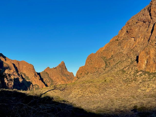
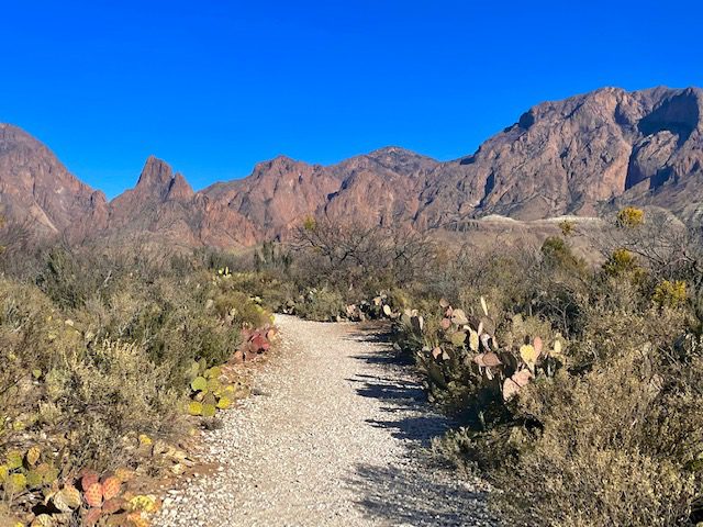
Chisos Basin
The Chisos Basin area is the most popular area of the park and is in a small area compared to the vastness of the rest of the park. Therefore, this part of Big Bend is very congested, and I recommend arriving here early in the morning.
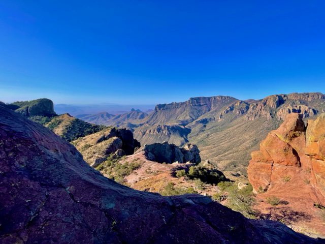
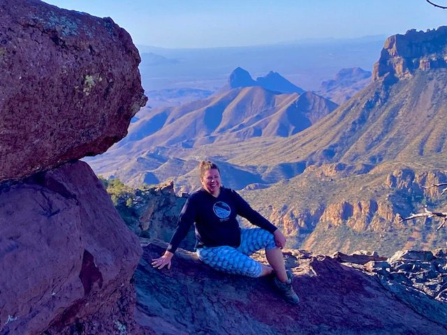
Lost Mine Trail
- Trail Length – 4.8 miles
- Elevation Gain – 1,131 feet
- Difficulty Rating – Moderate
- Route Type – Out and back
- Parking Situation – The parking at the trailhead holds around 15-20 vehicles. There are a couple nearby pullouts that hold a few cars each that you may luck into, but this will add to your overall trail length. When we went, the parking lot was full by 7:15 am. (And sunrise wasn’t until 8:05 am.)
- Restroom Situation – There are no restrooms in the parking area.
This is one of the most popular hikes in the park and for good reason. The views of Big Bend from atop this Big Bend hikes are like no other. This trail is the most difficult of all listed in this article. The trek up the trail is filled with switchbacks, but the view is worth it.
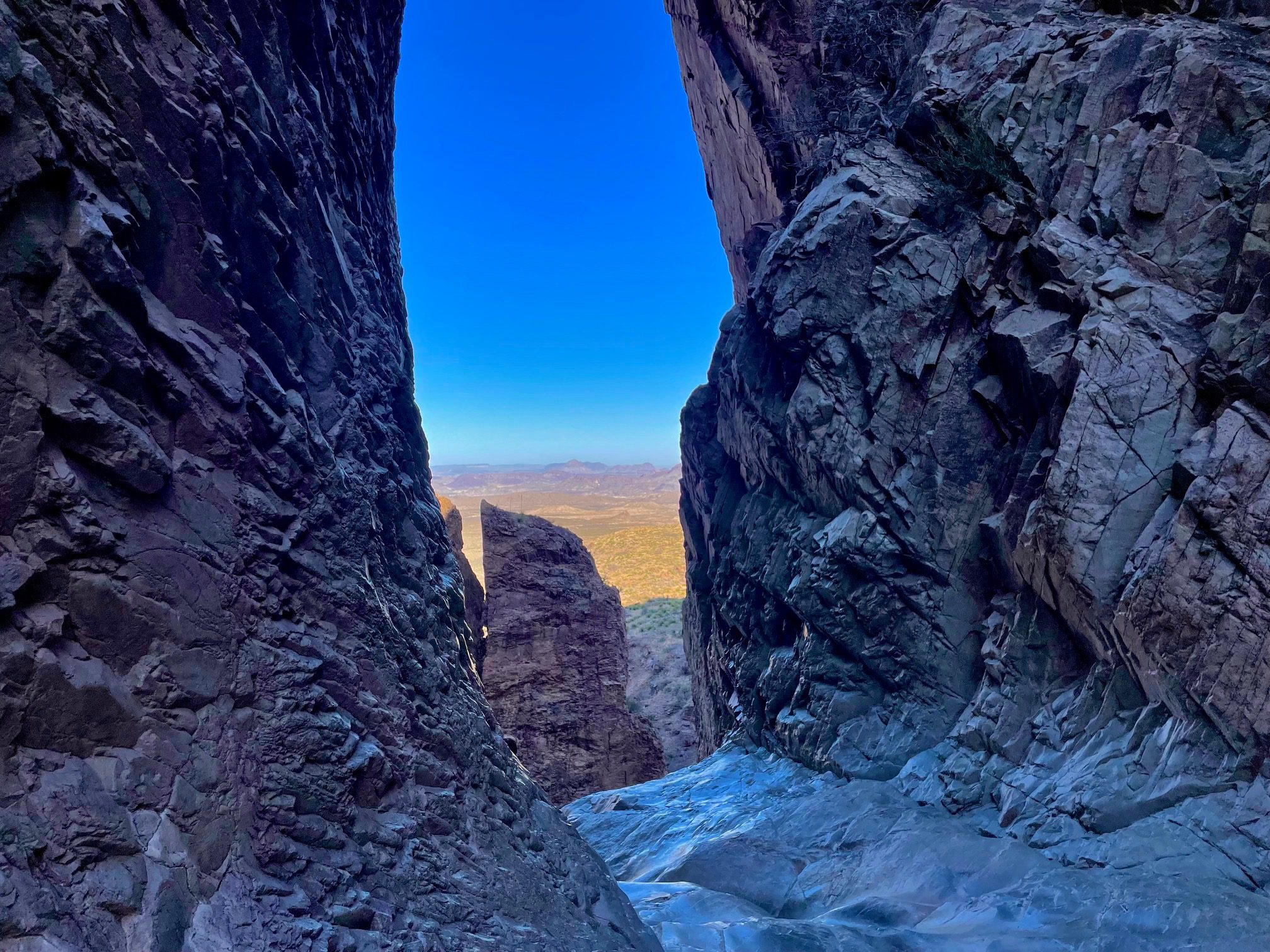
The Window Trail
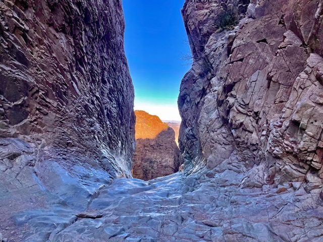
- Trail Length – 5.2 miles from official trailhead, or 3.6 miles if you start from Campsite 51. From the trail parking lot, walk through the campground and follow signs to Campsite 51 to cut 1.6 miles from your hiking distance.
- Elevation Gain – 948 feet
- Difficulty Rating – Moderate
- Route Type – Out and back
- Parking Situation – The parking area is larger than most and holds 80-100 vehicles.
- Restroom Situation – Restrooms are available in the campgrounds.
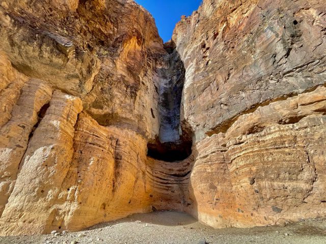
The Window Trail is a fun hike filled with rock scrambling and ends with an amazing view through a narrow window formed by water runoff. This hike is mostly downhill to the window, so the real challenge begins as you return to the parking area as it is all uphill.
Basin Loop Trail
- Trail Length – 2.4 miles
- Elevation Gain – 465 feet
- Difficulty Rating – Easy
- Route Type – Loop
- Parking Situation – Parking is in the Chisos Basin Visitor Center and Lodge lots which holds around 150 vehicles.
- Restroom Situation – Restrooms are available near the Visitor Center.
This moderately easy trail has great views of the Chisos Basin and takes you through a path surrounded by Mexican pine, oak and juniper. This trail can be hiked in either direction but counterclockwise is the easier path.
Window View Trail
- Trail Length – 0.4 miles
- Elevation Gain – 16 feet
- Difficulty Rating – Easy
- Route Type – Loop
- Parking Situation – Parking is in the Chisos Basin Visitor Center and Lodge lots which holds around 150 vehicles.
- Restroom Situation – Restrooms are available near the Visitor Center.
This short hike descends to a viewpoint to see the window pour-off from a distance. The walk from the viewpoint to the parking area is uphill. You can also see the droves of people hiking towards The Window.
Ross Maxwell Scenic Drive
This was my favorite area of the Big Bend hikes. These hikes are in order from the Castolon/Santa Elena junction to the end of the road at the Santa Elena trailhead.
Sam Nail Ranch Trail
- Trail Length – 0.3 miles
- Elevation Gain – 29 feet
- Difficulty Rating – Easy
- Route Type – Loop
- Parking Situation – A pullout offers enough parking area for 6-8 vehicles.
- Restroom Situation – No restrooms are available here.
This trail is an easy stroll through desert vegetation with mountain views surrounding you. This loop takes you past a rundown windmill and to the ruins of Sam Nails Ranch home.
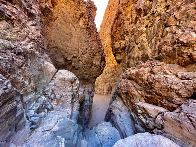
Upper Burro Mesa Pour-Off Trail
- Trail Length – 3.5 miles
- Elevation Gain – 459 feet
- Difficulty Rating – Moderate
- Route Type – Out and back
- Parking Situation – A pullout offers enough parking area for 10-12 vehicles.
- Restroom Situation – No restrooms are available here.
This trail was not on our original itinerary but was recommended by a park ranger, so we decided to add it. What a treat! This hike takes you through small canyons as you rock scramble towards the Burro Mesa pour-off, which resembles The Window. The final downhill climb before seeing the window is easy to get down, but may not be so easy to get up. We had a chain of people helping each other, so it was no problem for us. This hike ended up being most of the group’s favorite trail of the trip.
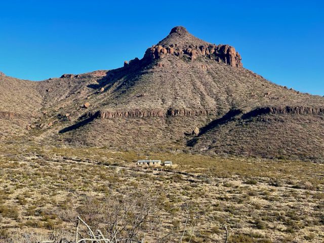
Homer Wilson Ranch Trail
- Trail Length – 0.7 miles
- Elevation Gain – 78 feet
- Difficulty Rating – Easy
- Route Type – Out and back
- Parking Situation – A pullout offers enough parking area for 10-12 vehicles.
- Restroom Situation – No restrooms are available here.
The Homer Wilson Ranch home is in much better shape than the Sam Nail house. Take the short trail to the house to explore the insides and surrounding areas.
Lower Burro Mesa Pour-Off Trail
- Trail Length – 1.0 miles
- Elevation Gain – 144 feet
- Difficulty Rating – Easy
- Route Type – Out and back
- Parking Situation – Parking area for 18-20 vehicles.
- Restroom Situation – No restrooms are available here.
After completing the Upper Burro Mesa Pour-Off Trail, make sure to walk the short and easy Lower Burro Mesa Pour-Off Trail, so you can see where your Upper hike ended. You can truly appreciate the height at which you were standing on the edge.
Mule Ears Spring Trail
- Trail Length – 3.9 miles
- Elevation Gain – 410 feet
- Difficulty Rating – Moderate
- Route Type – Out and back
- Parking Situation – Parking area for approximately 25 vehicles. This parking area is shared with the Mule Ears View Point.
- Restroom Situation – No restrooms are available here.
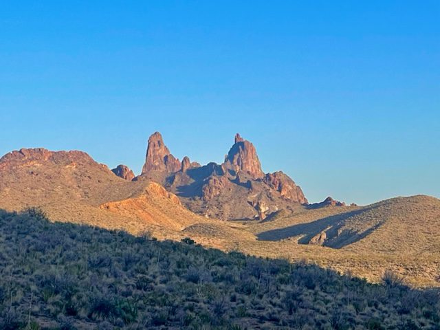
The hike to the Mule Ears Spring was also recommended by the park rangers, but we ran out of time to get this hike done. The trail takes you to a spring and offers closer views of the Mule Ears rock formation. If you do not complete this hike, at least walk to the Mule Ears View Point.
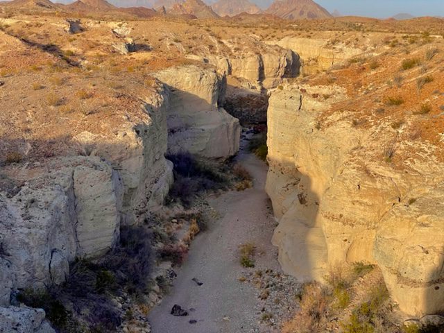
Tuff Canyon Trail
- Trail Length – 1.0 miles
- Elevation Gain – 144 feet
- Difficulty Rating – Easy
- Route Type – Out and back
- Parking Situation – A pullout offers enough parking area for 15-18 vehicles.
- Restroom Situation – No restrooms are available here.
Tuff Canyon offers three overlook platforms so you can see the canyon from above as well as a trail that leads you through the canyon walls below. At the end of the trail is a lava rock playground where you can spend a lot of time rock climbing and exploring.
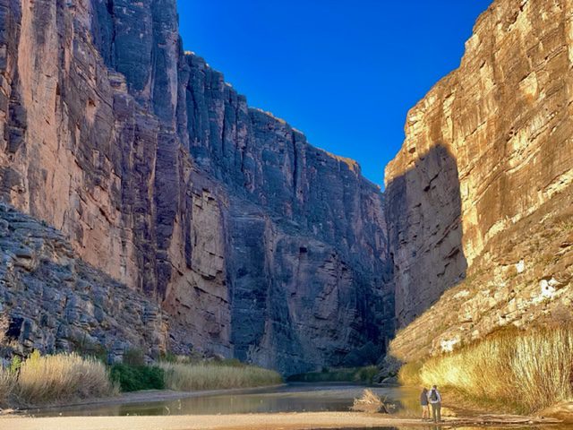
Santa Elena Canyon Trail
- Trail Length – 1.4 miles
- Elevation Gain – 157 feet
- Difficulty Rating – Easy
- Route Type – Out and back
- Parking Situation – The parking lot can fit approximately 30-35 vehicles.
- Restroom Situation – Pit toilets are available in the parking lot as well as the Santa Elena River Access parking lot.
Santa Elena Canyon Trail is a beautiful walk along the Rio Grande River that has carved through the massive canyon walls. The canyon wall on the right is the United States, and the canyon wall on the left is Mexico. This is also a popular spot to put in canoes and kayaks and paddle through the river that separates the two countries. As an added bonus, we spotted many fossils buried in the large rocks.
Rio Grande Village
All Big Bend hikes in this region are in order from the Grapevine Hills Road to the Boquillas Canyon along Park Route 12.
Balanced Rock via Grapevine Hill Trail
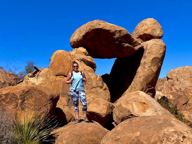
- Trail Length – 2.0 miles
- Elevation Gain – 246 feet
- Difficulty Rating – Easy
- Route Type – Out and back
- Parking Situation – The parking area is big enough for around 12-15 vehicles. People were also parking on the shoulder of the road and hiking to the trailhead.
- Restroom Situation – No restrooms are available here.
After an exhiliarating 6-mile, 4×4 drive on Grapevine Spring Road, you will have an easy, flat walk most of the way. Your last bit is a steep, rock scrambling climb to the epic Balanced Rock. While the balanced rock is a sight to see, the rock scrambling is what makes this Big Bend hikes super fun!
Dugout Wells / Chihuahuan Desert Nature Trail
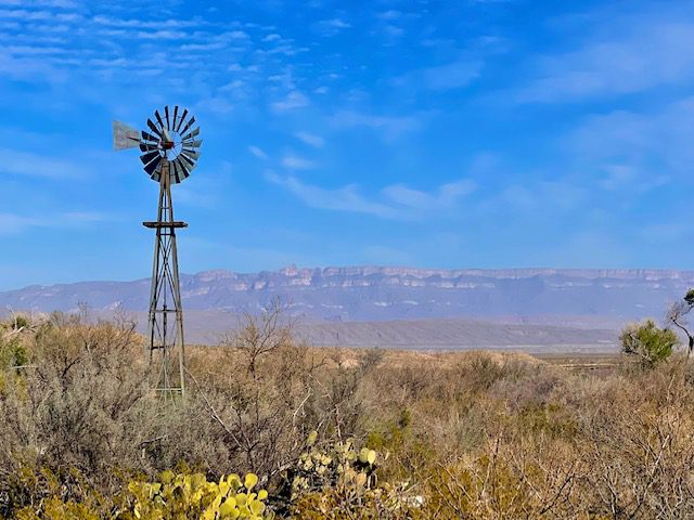
- Trail Length – 0.5 miles
- Elevation Gain – 36 feet
- Difficulty Rating – Easy
- Route Type – Loop
- Parking Situation – The parking area can fit around 15 vehicles.
- Restroom Situation – Pit toilets are available here.
The Chihuahuan Desert Nature Trail is an easy walk that offers many educational facts about Big Bend plants that grow and wildlife that flourishes here. This trail also features a working windmill and views of the Chisos Mountains.
Big Bend Hot Springs Trail
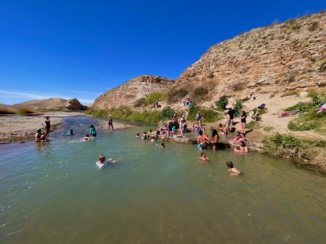
- Trail Length – 1.2 miles
- Elevation Gain – 144 feet
- Difficulty Rating – Easy
- Route Type – Loop
- Parking Situation – The lower parking area is large enough to fit around 15 vehicles. There is an upper parking area which also holds around 15 vehicles and is a 0.5-mile walk to the lower parking area.
- Restroom Situation – Pit toilets are available here.
Bring your swimsuit with you on this Big Bend hikes! Whether you are wanting to cool off in the Rio Grande River or soak in the natural Hot Springs, this trail is a nice break from constant walking. There is also a beautiful swimming hole by the picnic tables where some people were cliff jumping.
Ernst Tinaja Trail
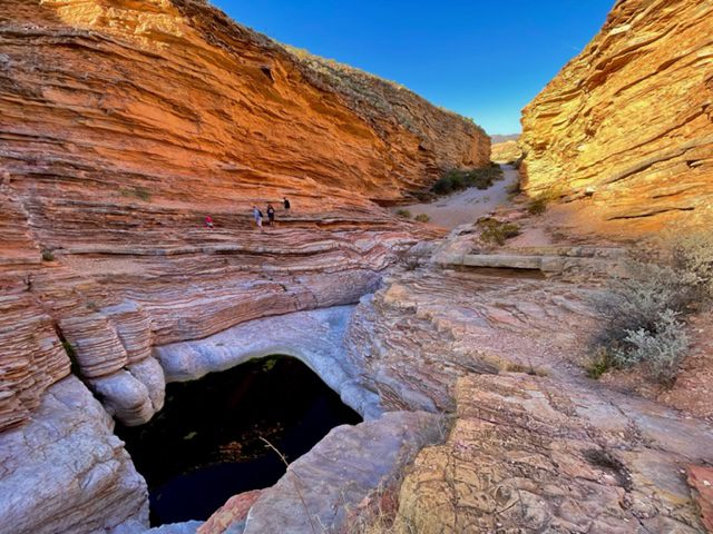
- Trail Length – 1.9 miles
- Elevation Gain – 131 feet
- Difficulty Rating – Easy
- Route Type – Out and back
- Parking Situation – A pullout offers enough parking area for 8-10 vehicles.
- Restroom Situation – No restrooms are available here.
From the main road, you will travel 5 miles on the rough terrain, Old Ore Road, before reaching the trailhead. You will likely need a 4×4 vehicle for this drive. Along the way, stop at the mysterious grave of Juan de Leon. Once at the trailhead, it is an easy stroll to the canyon that were carved from flash floods. This is where the real fun begins! Explore and rock climb through the canyon to see some magnificent rock formations.
Boquillas Canyon Trail
- Trail Length – 1.2 miles
- Elevation Gain – 229 feet
- Difficulty Rating – Easy
- Route Type – Out and back
- Parking Situation – The parking area can fit approximately 15-18 vehicles.
- Restroom Situation – No restrooms are available here.
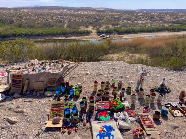
This trail climbs down a low hill to the Rio Grande River that separates the United States and Mexico. Near this trail is the Boquillas Overlook where you can purchase (illegal) souvenirs from Mexico. Also nearby is the Boquillas Crossing, where you can cross into Mexico. Make sure you bring your passport if you plan to cross the border.
You May Also Be Interested In
New Mexico Road Trip: 5-Day Itinerary
The Best of Sedona: Things to Do
How to Spend an Amazing 3 Days in Sedona, Arizona
Top Things to Do in Wimberley, Texas
How to Spend a Weekend in Pedernales Falls State Park in Texas
