Moab, Utah is well-known for its beautiful desert-like landscape with unique sandstone formations. You could spend days exploring the area via 4×4 vehicles, helicopters, rafting, and hiking. However, some of the most famous landmarks can only be accessed by hiking. The landscapes and rock formations that Moab is famous for are constantly changing from erosion. Some change slowly, but some can crumble away in a blink of an eye with a heavy gust of wind or a damaging flash flood. So you should not wait to visit. Here are the best Moab hikes you should experience immediately!
Disclaimer: This post may contain affiliate links so if you make a purchase or booking through one of our links we might earn a small commission (but don’t worry, it’s no extra cost to you).
Best Time to See Arches to Canyonlands
The best time for Moab hikes is during the shoulder months of the summer season: April, May, September, and October. Temperatures during this time range from 60 to 80 degrees F. Summer months Utah are scorching hot plus the summer crowds can make it difficult to get all the highlights done in one day. Winters can be cold and snowy.
How to Get to Moab, Utah
Moab is a small town in Utah with a population of over 5,000 people and not close to any major city. So you will have to drive to get to the Moab hikes. The closest major airport is Salt Lake City International Airport (SLC) which is almost 4 hours away. Take US-6 east to US-191 south.
Grand Junction Regional Airport (GJT) is under 2 hours away. This is a good option to fly into because it is relatively close to some Colorado parks such as Black Canyon of the Gunnison National Park and Colorado National Monument. The quickest way is to take I-70 west and then US-191 south. There is a scenic route that only takes 10 minutes longer and travels along the Colorado River through a canyon. The views are stunning and totally worth the few extra minutes. For this beautiful route, take I-70 west to UT-128 west.
Entrance Fees for Arches, Canyonlands, and Dead Horse
You will need to purchase a park pass to enter each of the national parks. The entrance fee to each park is $30 per vehicle for a 7-day pass. You may want to consider purchasing an America the Beautiful park pass, which will allow you into all national parks for a year for one single fee. The American the Beautiful Interagency pass is $80, and the costs to both parks is $60, so you are close breaking even on the pass. Also, if you have a 4th grader in your household, you can get a family pass for free to the national parks that is good for a year. Find out more about that benefit here.
Timed Entry Permits: Arches National Park has recently started a timed entry permit requirement. If you are planning on visiting between April 1 – July 6 and August 28 – October 31, 2025, you will need to purchase a timed entry permit from recreation.gov. If you arrive during these days, you can avoid getting a permit by arriving before 7am or after 4pm.
Dead Horse Point State Park is $20 per day per vehicle to enter. This park does not accept the America the Beautiful Interagency pass.
Where are the Best Moab Hikes
What to Pack for Your Moab Hikes
- Water!! Whether you use a hydration backpack or carry bottled water, make sure to pack plenty of water when outdoors! The visitor centers at each national park have water filling stations.
- Sunscreen – Protect your skin from the sun, and do not forget to reapply.
- Hat – More sun protection to block the sun from your face
- Hiking shoes/boots – Some of the hikes are on steep, slick rock, and people wearing regular tennis shoes struggled to keep their footing. Here are the men‘s version of the hiking shoes I love.
- Hiking socks – The best way to prevent blisters is by keeping your feet dry. Moisture-wicking socks are the best way to do that.
- Backpack – A backpack is a necessity when hiking to carry your water, snacks, sunscreen, etc. that you may need on your longer hikes.
- RTIC Soft-Sided Cooler – Keep your drinks and sandwich stuff cool in this cooler.
- Jacket – Even in warmer months, the temps can be cool in the mornings and evening so pack a light men’s or women’s jacket.
- Printed Maps/Directions – Cell service is spotty, so I recommend you print maps/directions or download offline maps to all hiking trails and parks you plan to visit.
Best of Moab Hikes
1. Delicate Arch Trail
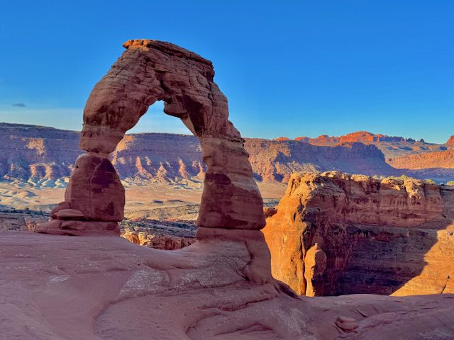
- Trail Length – 3.2 miles
- Elevation Gain – 629 feet
- Difficulty Rating – Moderate
- Route Type – Out and back
- Park – Arches National Park
Have you ever seen the arch on the Utah license plates? It is the iconic Delicate Arch which makes this one of the Moab hikes that you absolutely cannot miss. As such, it is a very popular and crowded hike, so I would recommend hiking this trail first thing in the morning. Most of the 1.6-mile one way trek to the arch is an easy, steady hill path. However, there is one section of steep slick rock you have to make your way up. After you pass this one difficult area, be sure to look out for signs pointing the way, so you do not go off-trail accidentally. The last little jaunt takes you around a sandstone hill. This part of the trail is about 3 feet wide and has steep drop-offs on one side.
Once you arrive, you will see the Delicate Arch on the edge of a cliff across from a giant erosion-carved bowl. You will likely have to wait in a line to get pictures of yourself inside the arch.
2. Corona and Bowtie Arch via Corona Arch Trail
- Trail Length – 2.3 miles
- Elevation Gain – 462 feet
- Difficulty Rating – Moderate
- Route Type – Out and back
- Park – Bureau of Land Management
Corona and Bowtie Arch is one of the most popular Moab hikes outside Arches and Canyonlands National Parks. It is not too long, but can be difficult in some areas. Start the trail off by crossing railroad tracks. The train that traverses these tracks through a canyon carries potash from the largest potash deposit in North America. There is one ladder to climb as well as steep parts on slick rock. This hike involves drop-offs with cables anchored to posts to help guide you. If you are afraid of heights, this hike is not for you.
3. Windows Loop and Turret Arch Trail
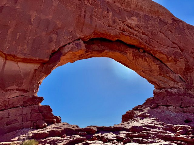
- Trail Length – 1.2 miles
- Elevation Gain – 154 feet
- Difficulty Rating – Easy
- Route Type – Loop
- Park – Arches National Park
Windows Loop and Turret Arch is an easy walk from the parking lot. The biggest challenge of this trail is finding a parking spot. Once you have secured parking, walk up the stairs to North Window (pictured above.) You can see both North Window and Turret Arch from the parking lot, but you will have to walk the trail to see South Window. You can climb right up to North Window and take your picture inside of it. But South Window is a little high to get inside. When you get to Turret Arch, you can scramble up the rock wall to get inside the arch. Finish the loop by walking back to the parking lot.
4. Double Arch Trail
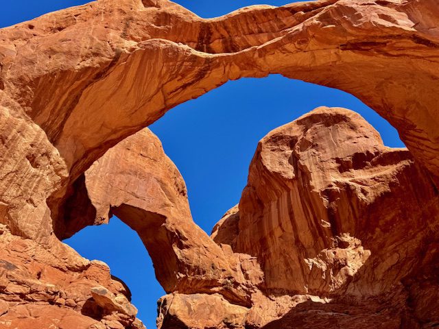
- Trail Length – 0.6 miles
- Elevation Gain – 95 feet
- Difficulty Rating – Easy
- Route Type – Out and back
- Park – Arches National Park
Double Arch is in the same parking area as the Windows and Turret Arch trail. You will need to take the stairs by the pit toilets down to the trailhead. Take the very short and very easy walk to the base of Double Arch for an up-close view of the giant arch twins. Even though the walk is short, there are several rock landforms to admire along the way such as the Parade of Elephants. Once you have arrived at the base of Double Arch, you can rock scramble up for a closer view of the arches.
5. Grand View Point Trail
- Trail Length – 1.8 miles
- Elevation Gain – 164 feet
- Difficulty Rating – Easy
- Route Type – Out and back
- Park – Canyonlands National Park
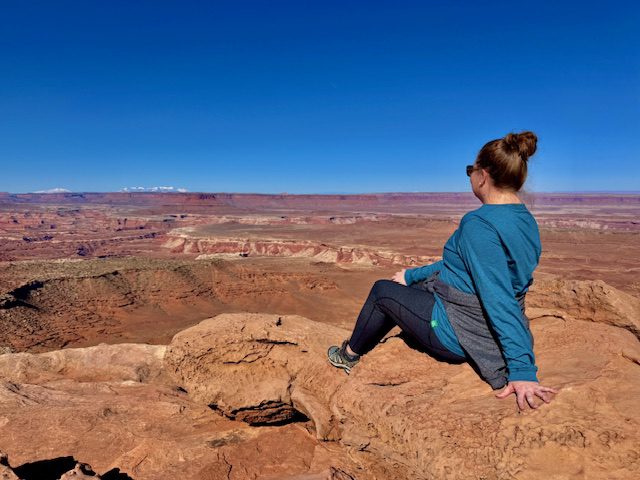
The Grand View Point Trail is a relatively easy trail that walks along the rim of a canyon cliff to a point where you can see canyon views for miles on a clear day. The first part of the trail is on a wide section that does have steep drop-offs on one side. You can walk right up to the edge to see more canyons with hoodoo formations below. Keep going along and follow the cairns to stay on-trail. When you get to the end of the trail, there is a pile of rocks that you can climb on top of. The 360-degrees from above this rock pile is like no other view among the Moab hikes.
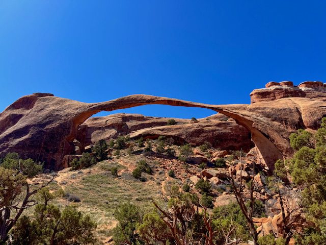
6. Landscape Arch Trail
- Trail Length – 1.9 miles
- Elevation Gain – 252 feet
- Difficulty Rating – Easy
- Route Type – Out and back
- Park – Arches National Park
Landscape Arch is the world’s longest natural stone arch beating out Zion’s Kolob Arch by just a few feet. In the past several decades, large rocks have fallen from the arch. Some have been the size of automobiles. Because of the unstable nature of the arch, people are no longer allowed to walk under the arch. You have to see it from the viewing area. Some believe the arch is near the end of its life and will crumble to pieces soon. However, others believe the arch has shed rocks to rebalance itself and has now become more stable. Only time will tell, but you should not put off seeing this arch while it is still around. The Landscape Arch trailhead is the same as the Devils Garden trailhead. You can extend your hike by doing the complete 7.9-mile Devils Garden Trail. There are also short offshoots to other arches such as Pine Tree and Tunnel Arches.
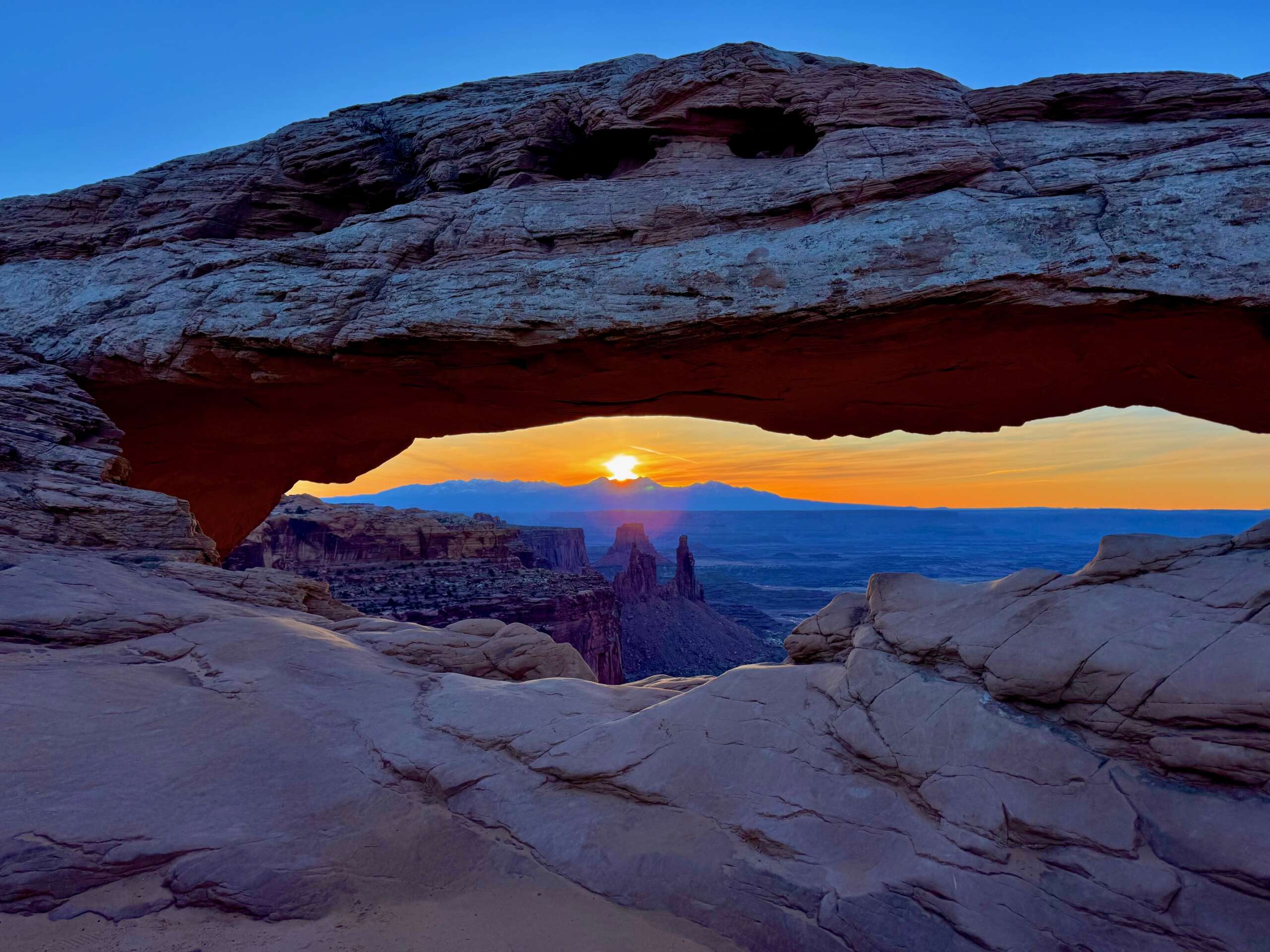
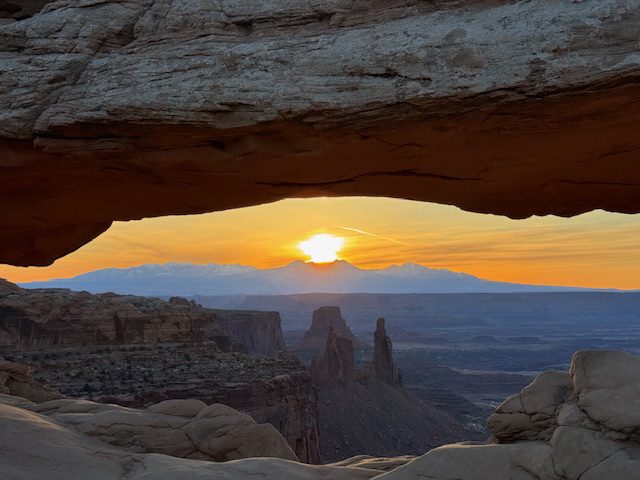
7. Mesa Arch Trail
- Trail Length – 0.9 miles
- Elevation Gain – 62 feet
- Difficulty Rating – Easy
- Route Type – Loop
- Park – Canyonlands National Park
Mesa Arch is the most iconic trail in Canyonlands National Park. It is a very short and easy loop to a cliffside arch. The opening of the arch is small compared to those in Arches National Park, but the views through the arch are legendary. you can see sandstone towers, cliffs, and canyons all the way to the La Sal Mountains. Anytime of the day is a great time to see Mesa Arch. However, if you want the most epic view of this arch, arrive for sunrise. The sun comes up over the mountains for the perfect view that encompasses the best of Utah. Make sure to get here at least 30 minutes before sunrise time because it gets very crowded with other sunrise chasers.
8. Upheaval Dome Trail
- Trail Length – 1.3 miles
- Elevation Gain – 226 feet
- Difficulty Rating – Moderate
- Route Type – Out and back
- Park – Canyonlands National Park
Upheaval Dome is a unique landform that is a complete mystery on how it was formed. There are two theories on how this circular depression was formed. One theory is that a salt dome cracked and tilted the rock over time. The other theory is that it is the result of a meteorite that fractured the rock. The only way to view the mysterious landform is by taking the Upheaval Dome trail. There are 2 viewpoints along the trail. If you are short on time or do not care to do the entire hike, you can stop at the first viewpoint and then head back. If you choose not to go to the second overlook, you can cut half a mile from your total trail length.
9. East and West Rim Loop
- Trail Length – 1.1 miles
- Elevation Gain – 370 feet
- Difficulty Rating – Easy
- Route Type – Loop
- Park – Dead Horse Point State Park
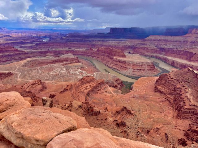
East and West Rim Loop is a trail that walks along the canyon’s edge in Dead Horse Point State Park with views of the Colorado River sculpting its way through the earth. The highlight of the trail is the Dead Horse Point Overlook where the Colorado River takes a sharp hairpin turn called gooseneck bend. The rim is 2,000 feet above the river and has miles and miles of canyon views. You can also bypass the hike altogether and drive straight to Dead Horse Point Overlook. This would be a remarkable spot to watch the sunset.
10. Fisher Towers Trail
- Trail Length – 4.2 miles
- Elevation Gain – 1,469 feet
- Difficulty Rating – Moderate
- Route Type – Out and back
- Park – Bureau of Land Management
Fisher Towers Trail is a bit different than the many arches and canyon Moab hikes that you experience in the area. This trail features ultra tall red sandstone towers along the moderately ranked pathway. You will pass the last large tower, the Titan, at about 1.5 miles into the hike. Continue to the end for a panoramic view of all the towers.
11. Fiery Furnace and Surprise Arch – CURRENTLY CLOSED
- Trail Length – 2.1 miles
- Elevation Gain – 492 feet
- Difficulty Rating – Moderate
- Route Type – Loop
- Park – Arches National Park
Fiery Furnace is a natural maze that winds between narrow passages and tall sandstone landforms. It is a hike not like any other. To access this trail, you must do a ranger-guided tour or obtain a Self-Guided Exploration permit prior to your arrival. Unfortunately, the park closed this unique hike in March 2025 amid staffing shortages.
You May Also Be Interested In
Arches to Canyonlands: How to Spend One Day
The Ultimate 2-Week Grand Circle Road Trip
A Whirlwind Utah Road Trip: 6 Parks in 7 Days
New Mexico Road Trip: A 5-Day Itinerary
Discovering Northern Arizona in 4 Days
The Perfect Las Vegas Day Trip to Grand Canyon and Hoover Dam
Valley of the Fire State Park: A Hiker’s Paradise Near Las Vegas
