Death Valley is the largest national park in the continental United States at over 3.4 million acres. There is no way you can explore the park in its entirety in 3 days, but you can certainly hit the best of this park during that timeframe. The variety of terrain at Death Valley will blow your mind…snow-capped mountains, painted hills, badlands, desert, salt flats, canyons, and a waterfall! You can spend 1, 2, or 3 days discovering all this park has to offer in this Death Valley itinerary.
Disclaimer: This post may contain affiliate links so if you make a purchase or booking through one of our links we might earn a small commission (but don’t worry, it is no extra cost to you).

Death Valley Itinerary – 1, 2, or 3 Days
How to Get to Death Valley
Death Valley National Park is located near the western border of California. The closest city is Las Vegas, Nevada which is about 2 hours away. There is no public transportation inside the park, so you will need to drive a car. Many of the roads are dirt roads and some require 4×4 vehicles. At a minimum, you should consider driving an SUV or other high clearance vehicle.
There is no specific address for Death Valley or Furnace Creek Visitor Center. Combine that with the little to no service in and around the park, I highly recommended you bring a road map or printed directions with you.
CA 190 from Death Valley Junction, CA: From Las Vegas, take NV-160 W and Pahrump Valley Highway to Bell Vista Ave in Pahrump for 66 miles. Turn left on W Bell Vista Ave and drive for 25 miles. Turn right on CA-127 N and make a quick left turn on CA-190 W for 18 miles.
SR 374 from Beatty, NV: From Las Vegas, get on US-95 N/Veterans Memorial Highway for 115 miles. Turn left on NV-374 S/Main St for 9 miles to park entrance.
Where to Stay at Death Valley
Some people just visit Death Valley as a day trip from Las Vegas, but if you are doing the 2 or 3-day Death Valley itinerary, you will need to find accommodations. You can camp inside the park, and there are also 3 hotels inside the park: The Inn at Death Valley, The Ranch at Death Valley (both at Furnace Creek), and the Stovepipe Wells Village Hotel in Stovepipe Wells, near Mesquite Flat Sand Dunes.
There are also hotel options in the nearby towns of Pahrump, Amargosa Valley, Shoshone, and Tecopa. For this Death Valley Itinerary, we stayed at Longstreet Inn Casino & RV Resort right on the California-Nevada border, about an hour away from the park. Longstreet was about a third of the price of the hotels inside the park, and it has a really good restaurant with decent prices.
Best Time of Year for this Death Valley Itinerary
Late fall, winter, and early spring are the best times to visit Death Valley. Spring is the busiest time because the temperatures are warming up, but not scorching. The wildflowers are also blooming The amount of blooms depend on how much rain the area received during the winter. The most crowded weekend is the Death Valley Dark Sky Festival. By May, Death Valley is too hot for most people to visit, and it doesn’t cool off until October. The least busy time of the year is after Thanksgiving but before Christmas.
Entrance Fees for Death Valley
The entrance fee to Death Valley is $30 per vehicle for a 7-day pass, or you can buy an annual pass for $55 . You may want to consider purchasing an America the Beautiful park pass, which will allow you into all national park services lands for a year for one single fee. The American the Beautiful Interagency pass is $80. Also, if you have a 4th grader in your household, you can get a family pass for free to the national parks that is good for a year. Find out more about that benefit here.
What to Eat and Drink
As I do for many of my hiking vacations, I carry a soft RTIC cooler to keep sandwich stuff and drinks cold. Unlike most national parks, there are restaurants inside the park. However, the menus are quite pricy. If you are doing the 2 or 3-day Death Valley itinerary, I recommend stopping at a grocery store in Las Vegas or in Pahrump to get water and stuff for a picnic lunch to carry into the park with you.
Map of Death Valley Itinerary
What to Pack for this Death Valley Itinerary
- Water!! Whether you use a hydration backpack or carry bottled water, make sure to pack plenty of water when outdoors!
- Sunscreen – Protect your skin from the sun, and do not forget to reapply.
- Hat – More sun protection to block the sun from your face
- Hiking shoes/boots – Some of the hikes are on steep, slick rock, and people wearing regular tennis shoes struggled to keep their footing. Here are the men‘s version of the hiking shoes I love.
- Hiking socks – The best way to prevent blisters is by keeping your feet dry. Moisture-wicking socks are the best way to do that.
- Backpack – A backpack is a necessity when hiking to carry your water, snacks, sunscreen, etc. that you may need on your longer hikes.
- RTIC Soft-Sided Cooler – Keep your drinks and sandwich stuff cool in this cooler.
- Jacket – Even in warmer months, the temps can be cool in the mornings and evening so pack a light men’s or women’s jacket.
- Printed Maps/Directions – Cell service is spotty, so I recommend you print maps/directions or download offline maps to all hiking trails and parks you plan to visit.
1-Day Death Valley Itinerary
If you only have time for a day trip, this Death Valley itinerary will hit the top highlights of the park. Start your day by driving the 2-hour drive from Las Vegas. To fit all these sites into your one day itinerary, you will need to get an early start. Try to be in the park no later than 9:00 am. Upon entry, you will need to stop at the self-pay kiosk to get your park pass. There are pit toilets here.
Zabriskie Point
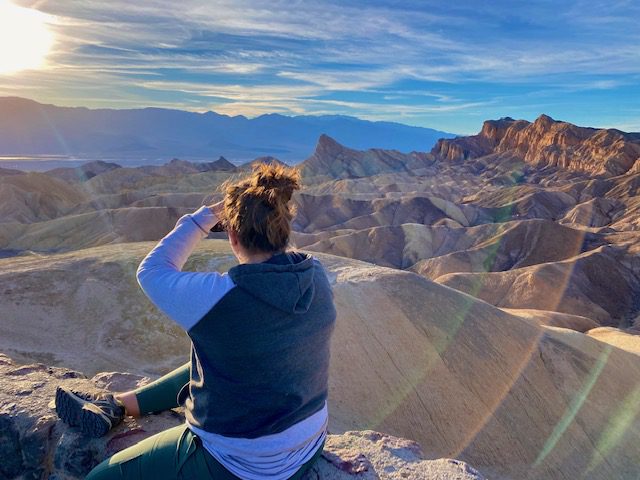
Your first stop on your Death Valley itinerary is Zabriskie Point which is a short but steep walk up to a viewpoint. From here, you can see the Death Valley badlands in the foreground with views of the salt flats and mountains in the background. This is a very popular spot for sunrise and sunset. After finishing here, stop at the Furnace Creek Visitor Center to grab a map and get up-to-date information from the park rangers.
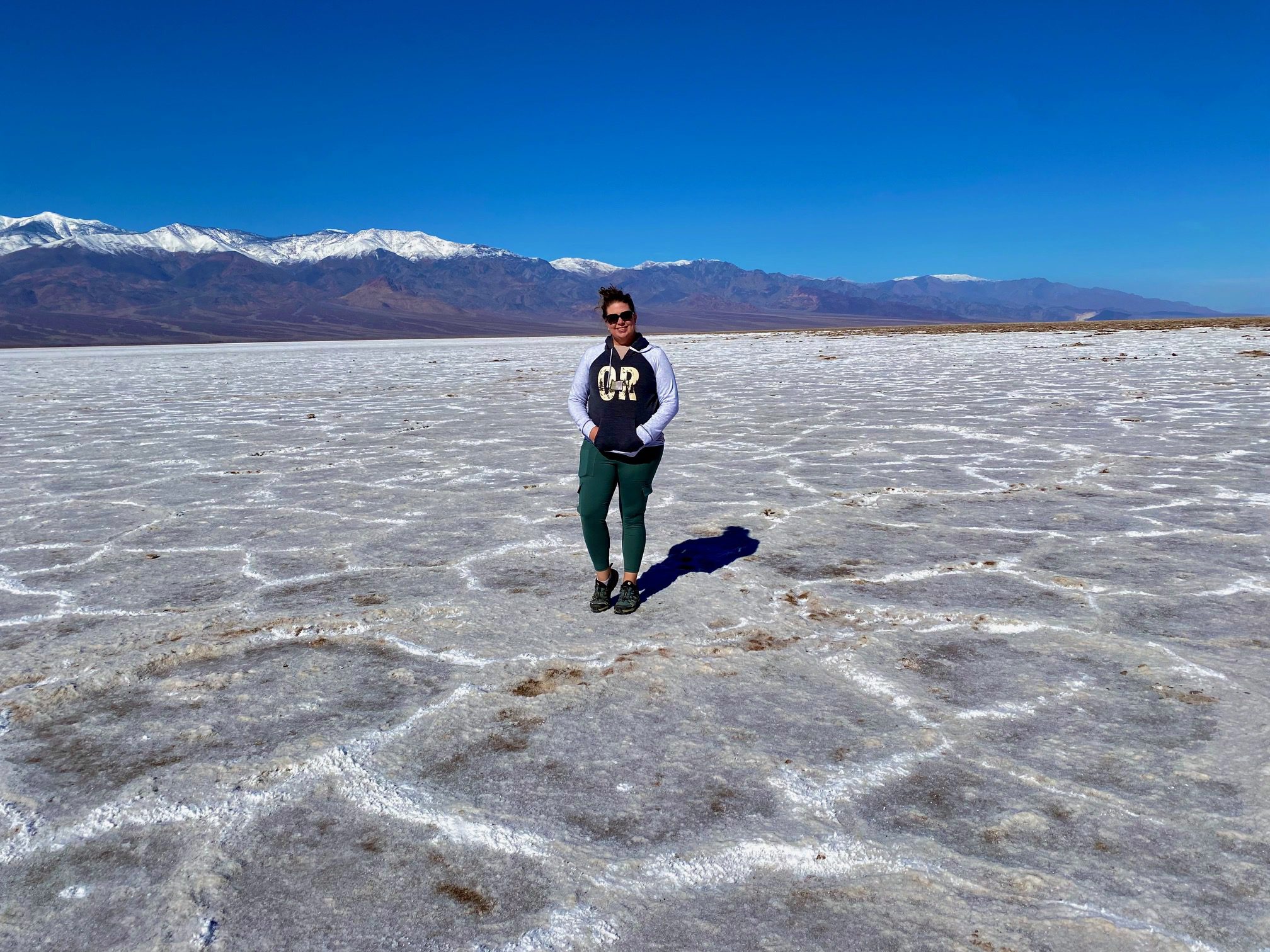
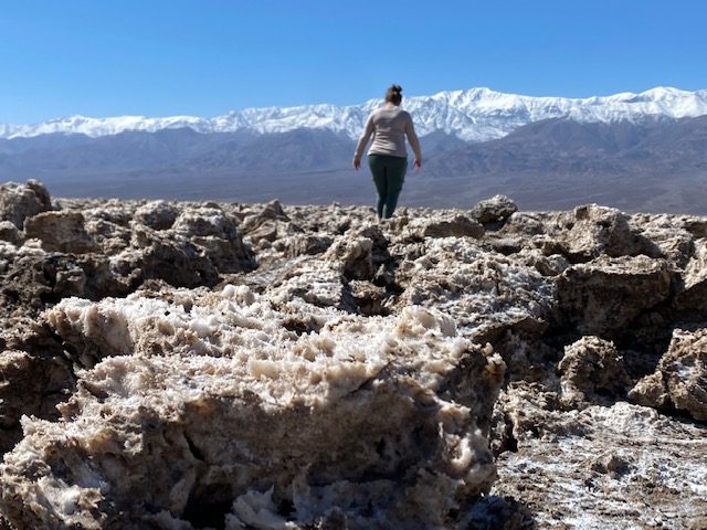
Badwater Basin Salt Flats
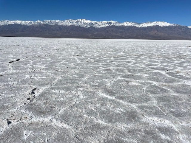
Badwater Basin Salt Flats is a truly unique terrain in this Death Valley itinerary. After you park, look up on the mountain side behind you and you will see a Sea Level sign 242 feet above your head. That is right – You are now at the lowest elevation on Earth! This spot also carries the hottest temperature on record at a balmy 134 degrees Fahrenheit (56.7 Celsius). Walk the short distance to the salt flats where you can walk onto the flats as far and as long as you like.
For millions of years, rainwater flooded this valley from runoff from the surrounding 9,000 square miles bringing lots of minerals with it. As the water evaporates over years and years, enough salts have been left behind to form these salt crusts.
Natural Bridge Canyon Trail
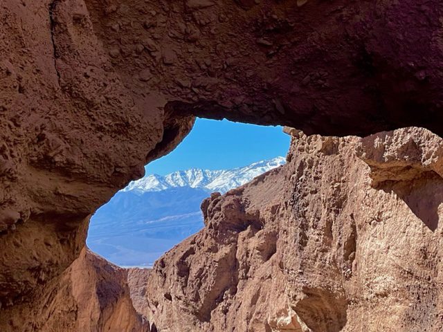
The next stop on the Death Valley itinerary is the Natural Bridge Canyon. From the parking area, you will reach the natural bridge after walking 0.3 miles between the canyon walls. The bridge is about 35 feet in width and also 35 feet high. From the backside of the bridge, you can get a window picture of the mountains in the background. Walk a short jaunt past the natural bridge to see the remnants of a flash flood waterfall.
Devil’s Golf Course
Drive the short distance to Devil’s Golf Course and walk around at your own risk. The crystallized salt forms into sharp jagged edges, and the terrain has been sculpted by winds and rains into a bumpy and uneven surface.
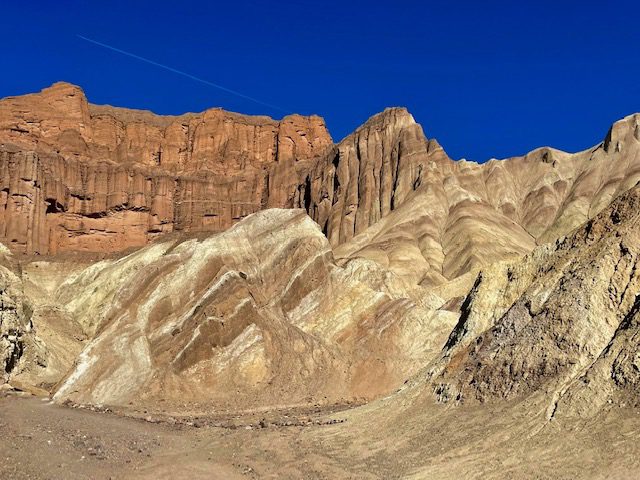
Artist’s Drive and Artist’s Palette
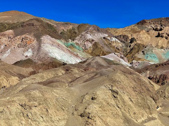
This almost 10-mile scenic drive features the rainbow-colored painted hills of Death Valley. Ancient volcanoes spewed ash and minerals all over this area which were chemically altered by heat, water, oxygen and other elements. The makeup of these painted hills include iron, aluminum, magnesium, titanium, red hematite, and green chlorite, but not copper. Stop at the Artist’s Palette along the drive and explore the hills at your will.
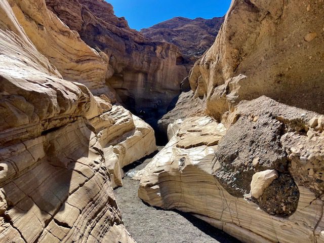
Desolation Canyon Trail
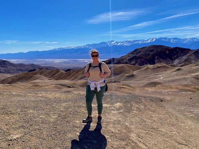
This 3.6-mile trek through narrow canyons leads you to a 360-degree panoramic view of Death Valley. You will have to scramble up 3 rock walls along the way, and the last 0.5-mile gets fairly steep. The views at the top will reward you for all your hard work. If you are not a hiker or this seems too strenuous, skip this part of the Death Valley itinerary. It is also important to note this trailhead does not have pit toilets, so make sure to take care of business elsewhere before beginning this hike.
Twenty Mule Team Canyon Scenic Drive
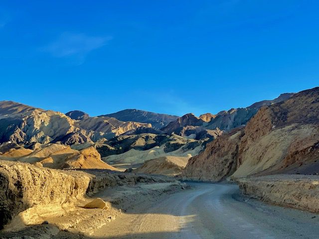
The last stop on your 1-day Death Valley itinerary is the 2.7-mile Twenty Mule Canyon Scenic Drive. This one-way road takes you between white badlands and canyons. This drive is located just past Zabriskie Point on your way out of the park. If you wanted to take in one last view at Zabriskie Point before leaving the park, now is your chance.
2-Day Death Valley Itinerary
For the 2-day Death Valley itinerary, do the 1-day itinerary above and then add the second day. To really get all the highlights of this national park, you really should plan on staying one night in the area and do 2 days. The second day was too beautiful to miss!
SR-190 Scenic Drive
You will begin the second day driving west along SR-190. All the stops for today are along this road. Take your time and take in the views along the route. There are a lot of pullouts on the way, more than just the ones highlighted here. Along the drive, you can stop at the General Store and Nugget Gift Shop at the Stove Pipe Wells area.
Devil’s Corn Field
The arrowweed plants that grow near the sand dunes resemble bundled corn left to dry in rows. Hence, this area was named Devil’s Cornfield. The root system of this plant adapted to the area by binding the soil around it as a way to hold onto the soil so it doesn’t erode away. Appropriately named, Native Americans used the stems of the arrowweed as arrow shafts.
Mesquite Flat Sand Dunes
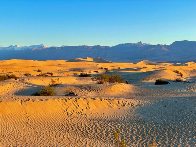
Mesquite Flat Sand Dunes are another unique sight to see in this Death Valley itinerary. The sand comes from the nearby eroding mountains. Winds blow the sands to this area but the surrounding mountains stop the sand from continuing their journey creating this sand dune field. There is no real trail here, but you can explore the dunes on your own.
Father Crowley Vista and Rainbow Canyon
Father Crowley Vista and Rainbow Canyon viewpoint is the farthest you will drive on SR-190 on this Death Valley itinerary. Take the short walk to the vista to get amazing views of Panamint Valley. From the parking area, you can also see Rainbow Canyon, also nicknamed Star Wars Canyon. Rainbow Canyon is appropriately named from its colorful striped hues formed by ancient volcanoes. The military uses this canyon as well as Panamint, Saline, and Eureka Valleys for low-level flight training. During our visit, we could hear the military jets flying about even though we couldn’t see them. Start heading back the way that you came on SR-190 to get to Darwin Falls.
Darwin Falls
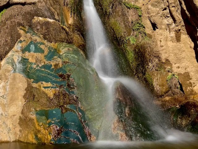
Darwin Falls is one of the few year-round waterfalls in Death Valley. To get to the trailhead, you will need to turn right on an unmarked gravel road just before you reach Panamint Springs. If you get to the town, you have gone too far. The 1.9-mile trail starts off easy enough with an easy, flat walk between two canyon walls. At some point the trail washed out from a flash flood and you will have to continue the hike in the creek bed. Follow the arrow made of rocks to know when to enter the creek bed. The water in the creek bed flows like a small babbling brook, so we did not get our feet wet. You may want to wear waterproof hiking shoes or water shoes for this hike. Towards the end of the trail, you will have to rock scramble over slick rock (with now wet shoes), so take care. You are greeted at the end of the canyon with a waterfall oasis.
Mosaic Canyon
The full Mosaic Canyon Trail is 3.3 miles, but can be much shorter should you choose to turn around at the boulder climb. The trail starts through narrow canyons with a few manageable rock scrambles up slick rock. The canyon then opens up fairly wide for a while before narrowing again at the boulder wall. Here most people turn back, but if you are capable of climbing up these boulders, you can continue. But the trail does not get easy after that. You will again have a series of semi-difficult rock scrambles up slick rock. Like Desolation Canyon, if you are not a hiker, this trail can be skipped on your Death Valley itinerary. A lot of people really love this trail, but I found it unremarkable. If I go back, I would skip this hike and save my hiking miles for another trail. This is another area that does not have pit toilets at the trailhead.
Harmony Borax Works
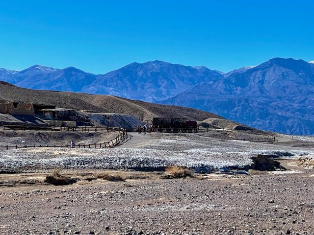
The remnants of the Harmony Borax Works, a borax processing facility built in the late 1800s after the discovery of borax, sits near the Furnace Creek area. To transport the processed borax out of Death Valley, employees used twenty mule teams and double wagons. This facility was only in operation for 5 years.
Explore The Ranch and The Inn Areas

The Ranch and The Inn at Death Valley are two of the lodging areas inside the park, but these areas also have other attractions. You can shop at the General Store or other gift shops. grab a bite to eat at one of the restaurants, and treat yourself to a couple scoops at the ice cream parlor.
3-Day Death Valley Itinerary
If you haven’t got your fill by now, add these stops for a full 3-day Death Valley itinerary.
Golden Canyon, Gower Gulch, and Badlands via Zabriskie Point
The first thing you should do today is the long, but epic, 6.4-mile Golden Canyon, Gower Gulch and Badlands loop. If you want to add the trek to the Red Cathedral from Golden Canyon, you will need to add 1 mile to your total mileage. You can start this loop at either the Golden Cathedral trailhead or Zabriskie Point.
If 6.4 miles is too much for you but you still want to hike, consider doing either Golden Canyon to Red Cathedral or the Badlands Loop Trails. The Golden Canyon to Red Cathedral trail is 2.9 miles and takes you through the canyon for about a mile before the rock scrambling begins. The trail ends at the top of Red Cathedral where you can get top down views of the surrounding canyons. Badlands Loop is a 2.7-mile trek that starts at Zabriskie Point. This trail takes you for a walk amongst the badlands. Hike the loop counter-clockwise to avoid steep inclines and also for better views.
Other Things You Can Do on Day 3
Unfortunately, we arrived shortly after a severe winter storm and flooding incident, so several of the roads were closed. Because of this, we were not able to do all the things we wanted to. However, to round out your 3-day Death Valley itinerary you can add these things to do. Most of which are scenic drives and viewpoints, so you do not have to do more hiking after the long 6.4-mile hike you just tackled.
- Ubehebe Crater
- Dante’s View
- Titus Canyon Road
- Titus Canyon Narrows
- Racetrack Valley Road
After you have completed your 1, 2, or 3-day Death Valley itinerary, you can either drive back to Las Vegas or your home location. Or you can continue your trip to other nearby national parks such as Joshua Tree, Kings Canyon, and Sequoia National Parks.
You May Also Be Interested In
The Ultimate San Francisco to Las Vegas Road Trip: 4 Parks in 7 Days
The Best 10-Day San Francisco to San Diego Road Trip
Kings Canyon and Sequoia National Parks in Once Day: How to See the Highlights
The Perfect 3-Day Yosemite Itinerary
Go On a National Park Roadtrip: 10 Amazing 1-Week Itineraries
The Ultimate 2-Week Grand Circle Road Trip

1 Comment
Comments are closed.