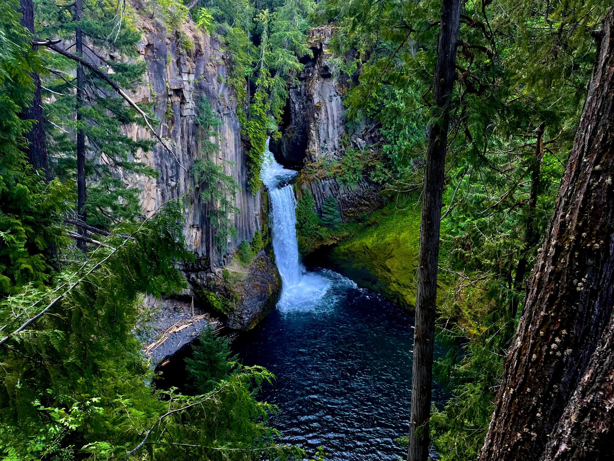
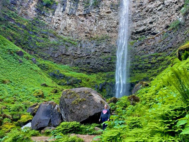
Do go chasing waterfalls! Especially the ones in Oregon. My favorite hikes are the ones where a waterfall is the main feature which is probably a huge reason why Oregon is my favorite state to hike in. There are still a handful of waterfall hikes that are on my bucket list, but I have not been able to hike them for various reasons. So this list may grow in the future. For now, this is my list of the best waterfalls in Oregon.
There are generally 7 regions of Oregon:
- Columbia River Gorge
- Willamette Valley
- Central Oregon
- Southern Oregon
- Eastern Oregon
- Oregon Coast
- Greater Portland
This list only includes waterfalls in the first 4 regions listed above. These areas are where most of the waterfalls in Oregon are located, so you will get more bang for your waterfall buck by visiting these 3 regions.
Waterfall Fees
Most of the waterfalls on this list require a $5 per day fee for parking and day use of the area. However, you can avoid these fees by displaying your Northwest Forest Pass for $30 or America, the Beautiful Interagency Pass (National Park pass) for $80. It may be worth purchasing one of these passes if you plan on visiting these sights or other sights covered by these passes. Each of these are good for a year, so it could definitely be worth the investment.
Columbia River Gorge
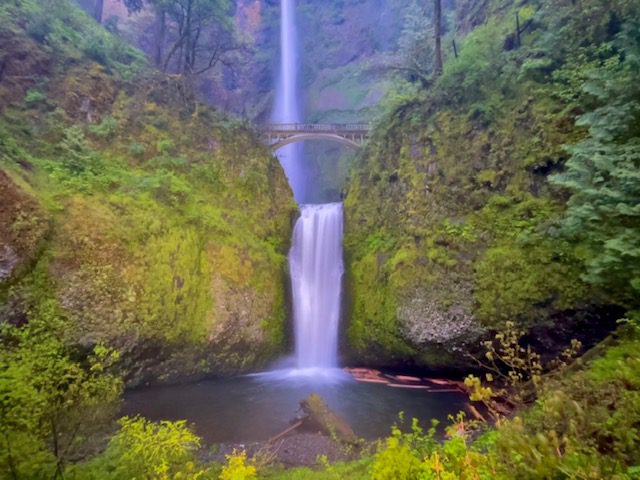
1. Multnomah Falls
- Trail Length – 2.4 miles
- Elevation Gain – 810 feet
- Difficulty Rating – Moderate
- Route Type – Out and back
- Parking Situation – The parking lot holds 186 cars but you must have a timed entry permit if visiting from late May to early September. Shuttles are an option.
- Restroom Situation – There are restrooms in the lodge and gift shop area.
Multnomah Falls is an iconic waterfall and is Oregon’s tallest at 620 feet. Views from the base of this waterfall are located just a short walk from the parking lot. Benson Bridge crosses Multnomah Creek and is only a 0.2 mile walk from the base of the falls. However, if you want to reach the top of Multnomah Falls, you will need to walk another mile up the 11 switchbacks. You can expect heavy crowds at this waterfall year round because it is one of the best waterfalls in Oregon, so I recommend arriving early to avoid gobs of people.
2. LaTourell Falls
- Trail Length – 2.0 miles
- Elevation Gain – 639 feet
- Difficulty Rating – Moderate
- Route Type – Loop
- Parking Situation – The parking area fits approximately 50 cars with additional parking on the side of the road.
- Restroom Situation – There are 2 pit toilets
LaTourell Falls is an incredible waterfall that you can see from two spots, both of which are short walks from the parking lot. The first is from a viewing platform, and the second is from the base of the falls. However, if you want to hike the full 3.0-mile loop, you can also see Upper LaTourell Falls. Most people stop at the first waterfall, so you can virtually have the trail to yourself if you complete the loop.
3. Dry Creek Falls
- Trail Length – 4.4 miles
- Elevation Gain – 885 feet
- Difficulty Rating – Moderate
- Route Type – Out and back
- Parking Situation – You can park at the Toll Bridge Park where there are 5-8 parking spots, or you can park at the Pacific Crest Trailhead where there are around 20 parking spots.
- Restroom Situation – There are flushable toilet restrooms at the Toll Bridge Park.
Dry Creek Falls, one of the best waterfalls in Oregon, is located on a short spur off the Pacific Crest Trail and starts at Toll Bridge Park at the Bridge of the Gods. Even though this hike is a little over 4 miles, it is not a difficult trek. The trail is a steady incline through a dense, green forest. At the 2 mile mark, you will reach an intersection where you will turn right to take the spur to Dry Creek Falls. Upon approaching the waterfall, you can cross the narrow concrete bridge to cross the creek and get closer to the base of the falls. For more details on how to hike this trail, see How to Hike Dry Creek Falls via PCT.
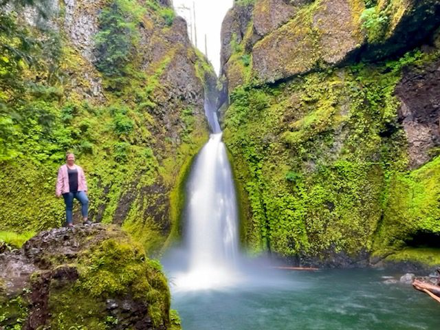
4. Punchbowl Falls
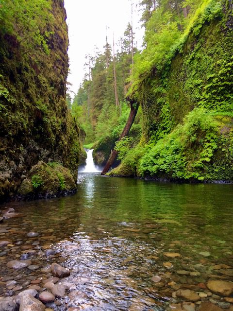
- Trail Length – 4.7 miles
- Elevation Gain – 1,046 feet
- Difficulty Rating – Moderate
- Route Type – Out and back
- Parking Situation – The parking lot holds approximately 40 vehicles.
- Restroom Situation – There are flushable toilet restrooms in the parking area.
Eagle Creek to Punchbowl Falls Trail leads you to one of the best waterfalls in Oregon, not only for the several waterfalls you can see along the way but also for semi-dangerous trail on the edge of a cliff. Do not attempt this hike if you are afraid of heights and steep drop-offs. Parts of this trail are carved out of a tall cliff and have chains anchored into the cliff walls that you can hold onto. The end of this route is Punchbowl Falls which you can see better after walking out onto rocks in the creek.
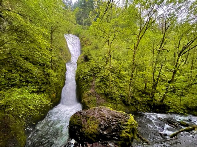
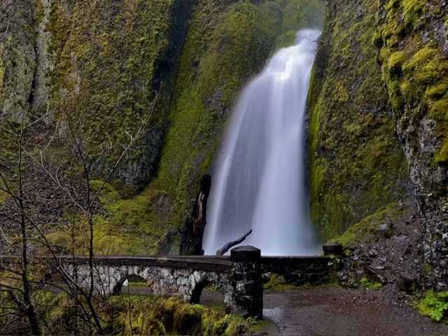
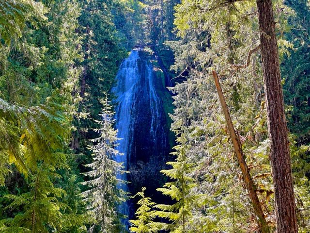
5. Horsetail Falls
- Trail Length – 0.9 miles
- Elevation Gain – 331 feet
- Difficulty Rating – Easy
- Route Type – Out and back
- Parking Situation – The parking lot holds approximately 40 cars.
- Restroom Situation – There no restrooms in this area.
Horsetail Falls is one of the best waterfalls in Oregon that can be seen from the parking lot. Do not make the mistake of stopping here though. Walk the trail to the top of Horsetail Falls and continue a bit until you get to Ponytail Falls. This is one of the few waterfalls in the area that you can walk behind. If you decide to walk even further, you can see Oneonta Falls after you walk down a few switchbacks and cross the bridge over Oneonta Gorge.
6. Bridal Veil Falls
- Trail Length – 0.5 miles
- Elevation Gain – 78 feet
- Difficulty Rating – Easy
- Route Type – Out and back
- Parking Situation – The parking lot officially holds around 20 vehicles but cars park along the road and grassy areas when busy.
- Restroom Situation – Nice restrooms with flushable toilets are available here.
The trail to Bridal Veil Falls is one of the shortest hikes and best waterfalls in Oregon. The trail takes you down a fairly steep decline and one switchback before you cross the bridge over Bridal Veil Creek. Then you will climb a few steps to the viewing platform and can watch as the double waterfall plunges into the creek below.
7. Wahclella Falls
- Trail Length – 1.9 miles
- Elevation Gain – 223 feet
- Difficulty Rating – Easy
- Route Type – Out and back
- Parking Situation – The parking lot holds approximately 10-12 vehicles.
- Restroom Situation – There are porta-potties in the parking area.
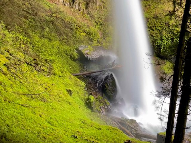
Wahclella Falls is my all time favorite waterfall hike in the Columbia River Gorge area which is saying a lot because all the waterfalls here are breathtaking. This hike starts along a creek laced with wildflowers. As you near the waterfall, you cross a bridge and see a ton of giant, moss-covered boulders. The waterfall itself is a powerful rush of water through a small opening into a turquoise pool making it truly a sight to see. This entire hike looks like something straight out of a fairytale.
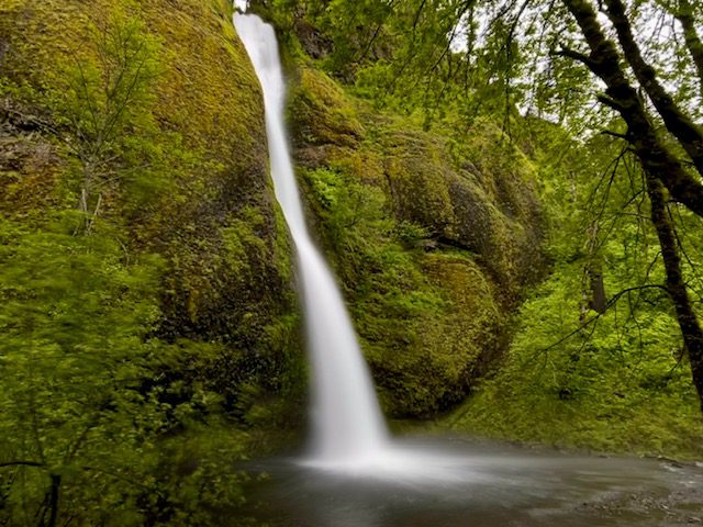
8. Wahkeena Falls
- Trail Length – 0.5 miles
- Elevation Gain – 260 feet
- Difficulty Rating – Easy
- Route Type – Out and back
- Parking Situation – The parking lot holds approximately 40 vehicles.
- Restroom Situation – There are no toilets here, but just down the street are the Multnomah restrooms.
You can actually see the Wahkeena Falls from the parking lot area, but it is so worth the short hike to the waterfall to see it up close. I was not that impressed with the waterfall until after I walked right up to it. If you are willing to walk an extra 1.8 miles roundtrip, you can get a view of Fairy Falls, which is a waterfall that deserves an honorable mention.
9. Tamanawas Falls
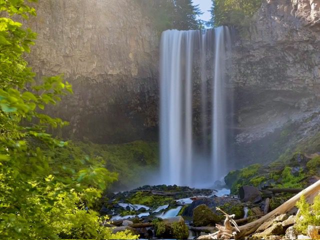
- Trail Length – 3.4 miles
- Elevation Gain – 580 feet
- Difficulty Rating – Moderate
- Route Type – Out and back
- Parking Situation – The parking lot holds approximately 30-40 vehicles.
- Restroom Situation – There are pit toilets here.
Tamanawas Falls are a little lesser known than its other Columbia River Gorge waterfalls, and that is likely because it is located past Hood River towards Mt. Hood instead of being on the waterfall corridor. The hike to this waterfall is nice and mostly covered in shade from large trees. The walk starts along the East Fork Hood River and then turns to the west along Cold Spring Creek.
Willamette Valley
10. South Falls – Silver Falls State Park
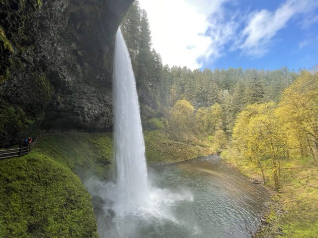
- Trail Length – 0.2 miles
- Elevation Gain – 193 feet
- Difficulty Rating – Easy
- Route Type – Out and back
- Parking Situation – There is a massive parking lot located near South Falls.
- Restroom Situation – There are restrooms nearby and in the café.
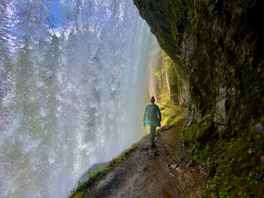
South Falls is a gushing waterfall that you can walk behind, but prepared to get soaked! This is the first of the Trail of Ten Falls in Silver Falls State Park. I have only listed 3 of the 10 waterfalls in this list, but honestly all 10 could easily have made this list. If you are ever in the area, you should walk the full 7.2 miles to see all the waterfalls. You will get the best bang for your buck that way. However, if you want to just see South Falls, it is just a short jaunt from the parking lot.
11. Middle North Falls – Silver Falls State Park
- Trail Length – 1.0 miles
- Elevation Gain – 250 feet
- Difficulty Rating – Easy
- Route Type – Out and back
- Parking Situation – There is a massive parking lot located near South Falls and another lot that holds around 20 vehicles at North Falls. The closest parking lot, though, is a small lot near Winter Falls (10 vehicles).
- Restroom Situation – There are restrooms nearby and in the café at the South Fall parking area.
Middle North Falls was my favorite of the Trail of Ten Falls and one of the best waterfalls in Oregon. I liked that the falls were wide, and you could walk behind them. There was also a lot more greenery surrounding these falls than the others which makes it stand out to me. The shortest route to get to these falls is by parking at the Winter Falls lot and walking 0.5 miles straight to the falls. However, by doing this, you miss out on a lot of other really great waterfalls. To get here from South Falls, it is around 2.7 miles one-way, and from North Falls, it is around 1.5 miles one-way.
12. North Falls – Silver Falls State Park
- Trail Length – 0.2 miles
- Elevation Gain – 150 feet
- Difficulty Rating – Easy
- Route Type – Out and back
- Parking Situation – There is a medium-sized lot that holds around 20 vehicles at North Falls.
- Restroom Situation – There are pit toilets in the parking area.
North Falls is similar in look and amount of water as South Falls. It is the perfect grand finale waterfall of the full Trail of Ten Falls in Silver Falls State Park. What is especially nice about this waterfall is the large carve out behind the waterfall. Not only can you walk behind it (which I love), but there is plenty of room to take a seat and really take in the view.
13. Sahalie Falls
- Trail Length – 0.1 miles
- Elevation Gain – 150 feet
- Difficulty Rating – Easy
- Route Type – Out and back
- Parking Situation – There is a medium-sized lot that holds around 20 vehicles.
- Restroom Situation – There is a porta potty in the parking area.
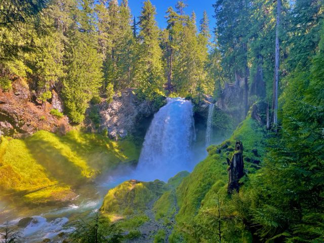
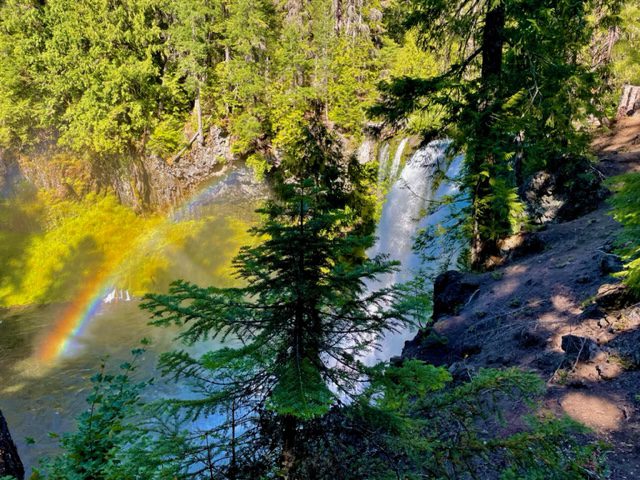
There is a parking lot and viewing area right at the falls location. However, there is a 2.9-mile loop trail that takes you to Koosah Falls, along the McKenzie River to the Carmen Reservoir. This waterfall was full when I visited and plunged violently into the river below.
14. Koosah Falls
- Trail Length – 0.1 miles
- Elevation Gain – 150 feet
- Difficulty Rating – Easy
- Route Type – Out and back
- Parking Situation – There is a small lot that holds around 10-15 vehicles.
- Restroom Situation – There are pit toilets here.
The trail length listed here is 0.1 miles because there is a parking lot and viewing area right at the falls location. However, you can walk here along the waterfall trail from Sahalie Falls along the McKenzie River. There is a viewing area at the top of the waterfall, or you can walk down the trail for a while to see the full waterfall.
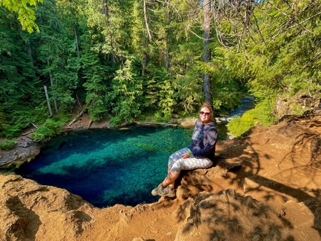
15. Tamolitch Falls (Blue Pool)
- Trail Length – 3.9 miles
- Elevation Gain – 351 feet
- Difficulty Rating – Moderate
- Route Type – Out and back
- Parking Situation – Parking along the road to the trailhead allows for approximately 60 cars. However, there is room for another 40 cars between the overflow lot and parking along McKenzie Highway (126).
- Restroom Situation – There are pit toilets here.
I rated this hike as moderate, only because of the trail length and it is difficult to get to the shoreline of the pool once you have arrived. However, the walk is fairly easy with only a moderate elevation change. The hike takes you along the McKenzie River and through moss-covered lava falls until you reach a crystal clear, vibrant blue pool that the Tamolitch Falls empties into. The best part of this hike isn’t the actual waterfall but the beautiful blue pool that you can swim in.
16. Proxy Falls
- Trail Length – 1.6 miles
- Elevation Gain – 147 feet
- Difficulty Rating – Easy
- Route Type – Loop
- Parking Situation – Often crowded parking and can fit around 20 cars along roadside pullouts.
- Restroom Situation – Pit toilets are located across the road.
Proxy Falls Loop is actually a trail that has two beautiful waterfalls: Upper Proxy Falls and Lower Proxy Falls. Walk through ancient lava fields as you begin the loop trail. If you are willing to get your feet a little wet, you can climb over wet rocks to get right up to Lower Falls. Before you get to the rocks, however, you will need to traverse a giant downed tree to cross Proxy creek.
Central Oregon
17. Tumalo Falls
- Trail Length – 0.2 miles
- Elevation Gain – 50 feet
- Difficulty Rating – Easy
- Route Type – Out and back
- Parking Situation – There is parking for 15-20 vehicles at the falls. However, there is overflow parking 0.5 miles away with a nice trail that leads to the falls.
- Restroom Situation – There are pit toilets here.
Located just 12 miles from Bend and in Deschutes National Forest, makes this waterfall the only one listed in the Central Oregon region. Tumalo Falls Viewpoint is just a short walk from the parking. Make sure to walk the quarter of a mile up the trail to get a closer view of the waterfall. However, if you are looking at adding a bonus waterfall, hike the 2.0-mile, easy out and back trail to Double Falls.
Southern Oregon
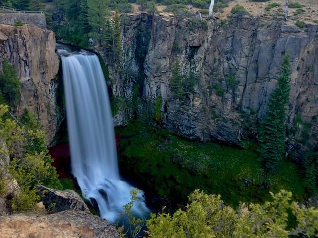
18. Salt Creek Falls
- Trail Length – 0.6 mile
- Elevation Gain – 223 feet
- Difficulty Rating – Easy
- Route Type – Out and back
- Parking Situation – There is room for approximately 50 vehicles.
- Restroom Situation – There is a restroom here but was closed for repair during my visit. A porta potty in the parking area can be used instead.
A view of Salt Creek Falls can be seen a short distance from the parking lot and is wheelchair accessible. Salt Creek Falls is Oregon’s second tallest single drop waterfall and is truly a sight to see. The viewing platform not only gives views of the waterfall but also the dense forest landscape. If you want to stretch your legs, consider taking the 0.6-mile trail to get a view of the waterfall closer to its base instead of high up.
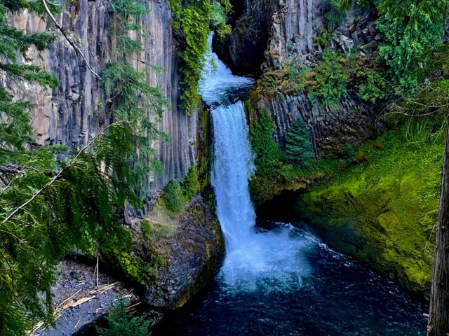
19. Toketee Falls
- Trail Length – 0.9 miles
- Elevation Gain – 167 feet
- Difficulty Rating – Easy
- Route Type – Out and back
- Parking Situation – The parking area can fit around 20 vehicles.
- Restroom Situation – There is a pit toilet in the parking area.
Toketee Falls is one of the most unique waterfalls in Umpqua National Forest. Because of this and its close proximity to Crater Lake National Park, it is often crowded with visitors. The official trail takes you to a viewing platform. But if you are feeling adventurous, you can crawl through the fence opening at the viewing platform and scale down the almost vertical hillside to reach the banks of North Umpqua River. From here, you can get an even more spectacular view of the waterfall.
20. Watson Falls
- Trail Length – 0.8 miles
- Elevation Gain – 360 feet
- Difficulty Rating – Moderately difficult
- Route Type – Loop
- Parking Situation – There is enough parking for 10-20 vehicles.
- Restroom Situation – There are pit toilets in the parking area.
Even though the hike to Watson Falls is short, I have ranked the hike as moderately difficult due to steep inclines most of the walk. At 293-feet in height, Watson Falls is the highest in Southwest Oregon. Just below the waterfall is a wooden bridge that offers a great view of the waterfall. But do not turn back there, the views just get better as you walk up the trail.
Honorable Mentions Waterfalls
The waterfalls mentioned here look like they would be really great, but unfortunately I have not been able to see them for myself to verify. Either the roads were washed out and my Toyota Corolla rental car couldn’t make it, or the roads were not open yet due to late winter snowfalls. Maybe someday I will be able to experience these waterfalls for myself, and they will make the best waterfalls in Oregon list.
- Abiqua Falls
- Plaikni Falls
- Hemlock Falls
- Yakso Falls
What to Pack when Hiking the Best Waterfalls in Oregon
- Water!! I recommend bringing a refillable water bottle or two. Oregon charges a tax on plastic bottles, so it is best if you use a refillable one. Not to mention, it is better for the environment!
- Bug Spray – Keep those pesky bugs away!
- Sunscreen – Protect your skin from the sun, and do not forget to reapply.
- Hat – More sun protection to block the sun from your face, but the hat can also keep rain off your face.
- Hiking shoes/boots – These are waterproof so walking on the beach or in muddy areas will not be a problem. Here are the men‘s version of the hiking shoes I love.
- Hiking socks – The best way to prevent blisters is by keeping your feet dry. Moisture-wicking socks are the best way to do that.
- Backpack – A backpack is a necessity when hiking to carry your water, snacks, sunscreen, etc. that you may need on your longer hikes.
- Rain Jacket – Rain can (and probably will) occur at some point while in Oregon, so make sure to pack your men’s or women’s rain jacket.
- Waterproof Pants – If visiting in the rainy season, waterproof pants will help keep your legs dry. Men’s Pants.
- Jacket – Even in warmer months, the temps can be cool so pack a light men’s or women’s jacket.
You May Also Be Interested In
The Best Day Trips from Portland, Oregon
The Greatest Oregon Road Trip: See the Best of Oregon’s Natural Wonders in 14 Days
How to Spend 3 Days Discovering the Oregon Coast
The Best Hikes in Columbia River Gorge, Oregon
The 18 Best Things to Do in Hood River, Oregon
How to Spend 3 Days Trekking the Columbia River Gorge


7 Comments
Comments are closed.